Millerston
The present-day community of Millerston covers an area north of the Cumbernauld Road, next door to neighbouring community Stepps. But Millerston wasn’t always here - it started life as a small village further west, on the opposite side of the road next to Hogganfield Loch.
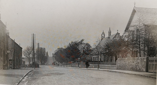
Ref: The original Millerston village, pictured some time between the 1860s and 1920s. On the other side of the houses on the left (which have since been demolished) lies Hogganfield Loch. The church on the right still stands. Image taken from ‘Old Riddrie, Millerston and Stepps’, John Hood, Stenlake Publishing, 2001.
The area in which the original Millerston village sat was once dominated by farmland. By the 19th century some industry had started to appear in the area, including small coal mines, limestone and fireclay mining, and ice manufacturing.
In the days before refrigeration, ice was a precious commodity, and Glasgow’s shops, cafes and restaurants were supplied with ice extracted from Hogganfield Loch. Maps from as early as 1859 show ice houses on the edge of the loch, where the ice would be stored and packed. The industry was not to last, however - when Norwegian ice became popular, shipped in via the new technology of refrigerated transport, it was the end of Hogganfield ice cubes in Glasgow’s drinks.
One theory for the community having the name Millerston was that it derives from “Miller’s town”, named after the Miller family of Frankfield, who had mills in the area - although this has not been proven.
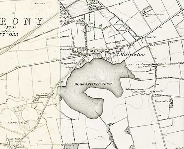
Ref: Map of Millerston,1859, showing the location of the original village. The Hogganfield Bleachfields can be seen to the west of Hogganfield Loch. Image: National Library of Scotland.
https://maps.nls.uk/geo/explore/#zoom=14.8&lat=55.88133&lon=-4.17773&layers=257&b=1
The earliest maps indicate no evidence of mills, but by 1865 the area was home to a large bleachworks, on the west side of Hogganfield Loch. This may lend some credence to the mill theory, as bleachworks were often found near mill towns at a time when textile manufacturing was a major industry in Britain. At the bleachworks, linen or cotton fabric was washed, processed, and laid out on large bleaching fields to whiten in the sunlight. After the introduction of chlorine bleaching processes, much of this processing was done indoors, where the fabric was also dried.
The works drew water from the Molendinar Burn and also from Loch Katrine, which has been Glagsow’s primary water supply since the 1850s. It is said at one time the bleachworks used up to 5,000 gallons of water a day.
The bleachworks provided employment for people - mainly young women - from across the area. Girls from as far as Chryston could be seen walking through Stepps on their way to the works at 5.30 each morning, working long days and not returning home until 6.30pm.
By the 1920s the bleachworks were in decline, and eventually closed. It is now the site of part of Lethamhill Golf Course.
People of Millerston
In the middle of the 19th century, Millerston was a collection of small cottages either side of the toll road between Glasgow and the old Cumbernauld village, with Hogganfield Loch to the south.
We know little about the people of Millerston at this time, except for an Ordnance Survey catalogue of 1858 which describes the houses of Millerston as being “occupied by the poorest class”.
The village centred around the church, the United Free Church of Millerston, which was built in 1859, and still stands today.
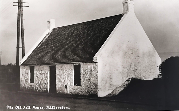
Ref: The Old Toll House, Millerston, date unknown. East Dunbartonshire Archives
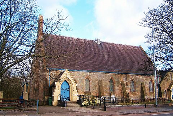
Ref: Millerston United Free Church.
https://www.ufcos.org.uk/congregations/millerston/
We can assume that most residents of the area worked as farmers, at the bleachworks or in one of a number of other trades. A register from 1873 lists the occupations of Millerston residents, and includes: the stationmaster at Stepps station, a gardener, blacksmith, a grocer, a shoemaker, gamekeeper, engineer, bookkeeper, the manager of the bleachfield works himself and at least 13 farmers. While an incomplete picture - these directories rarely listed the occupations of poorer people, or women - it nevertheless gives a glimpse of the type of people who lived in Millerston around this time.
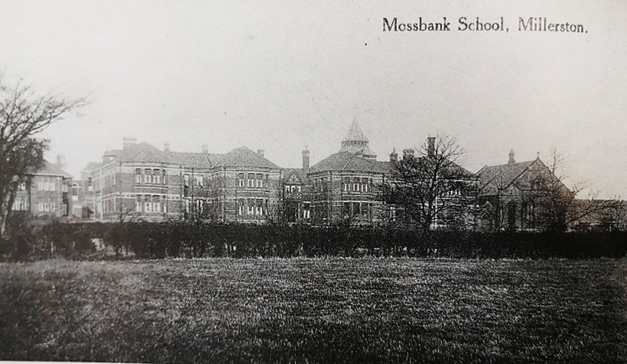
Mossbank School
Ref: Mossbank Industrial School. Image taken from ‘Old Riddrie, Millerston and Stepps’, John Hood, Stenlake Publishing, 2001.
By 1868, Millerston was also home to Mossbank Industrial School for Boys. It was one of a number of new schools of this type built at this time across Scotland, and elsewhere in the UK, to deal with problems of vagrancy and criminal behaviour in Britain’s children. Industrial schools were intended to remove poor and neglected children from their home environment, educating them and teaching them a trade.
Opened originally as an extension of the Glasgow Industrial School at Rottenrow, the school was intended to house 150 boys and girls. It was then decided to send the girls back to Rottenrow, and the school became Glasgow Boys’ Industrial School.
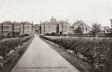
Ref: Mossbank Industrial School. Image: Media Storehouse.
https://www.mediastorehouse.co.uk/mary-evans-prints-online/moss-bank-industrial-school-millerston-glasgow-14147544.html
The superintendent of Mossbank School lived in Millerston village, and the boys also attended the church every Sunday. The church had a separate entrance up to a balcony to ensure the boys did not mix with the congregation when attending services. They reportedly had to leave at 12.30 even if the service had not yet finished - if ever this happened, the sermon and hymns would continue over the sound of the boys’ clattering boots as they left.
At one time, around 430 boys, aged eight to 15, attended the school. They received instruction in skills such as shoemaking, tailoring, paper bag making, baking and gardening, with the school laying out a four-acre garden to grow vegetables, fruit and flowers in 1899.
Conditions at the school were no doubt lacking in home comforts, and the boys who were sent there were sometimes in very poor health as a result of the conditions in which they grew up and were subsequently kept at the school. An inspection of the school in 1879 reported an “extraordinary” number of deaths had occurred there, with 21 deaths reported over the previous two years, and a further 17 boys discharged from the school on account of disease. The inspection recommended special provision should be made to improve the unhealthy situation of the school, including appropriate clothing and diet for the weak and unwell boys who lived there.
Despite the harsh conditions, the school also had its own band, a gymnasium and even a swimming pool - presumably built in the belief that exercise helped create strong and healthy citizens.
The school became an Approved School, a new type of school intended to replace the existing system of industrial schools and reformatories, in 1933. It continued to operate as a boys’ school, teaching skills including woodwork and boot repairing, over the next few decades. During the Second World War, the whole school was evacuated to Ardgoil in Argyll and Bute, where it was known as the Mossbank Boys’ Camp.
In the late 1960s the school was in line to be developed further, but by now the condition of the buildings had badly deteriorated, and the school was demolished. The site has now been grown over with young trees.
Another, regular school was built in Millerston in 1870, on the west of Hogganfield Loch between the bleachworks and the village. Before then, children from the area had to go to Ruchazie or Riddrie to go to school. This new school served Millerston, Hogganfield, the farms all around, and the growing village of Stepps, which did not get its own dedicated school until 1902.
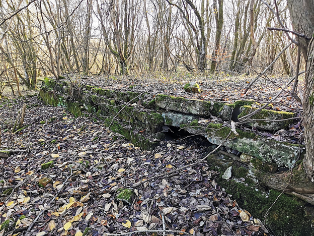
Ref: Site of the old Mossbank school, where only remnants of a wall remain. Image by Kayleigh Hirst
The Tower
One of the more curious landmarks of modern-day Millerston is a tall baronial-style tower house tucked away on a side street off Station Road.
The tower is thought to be a 19th century reconstruction of a 17th century style tower house and was originally part of a property known as Mossvale which also had some farm buildings. By the 1930s, the farm buildings had been demolished, leaving the Tower standing on its own. For years, the property lay derelict, at one point standing sentinel over a scrap metal merchant’s yard.
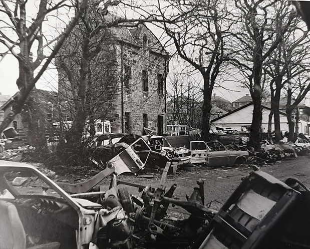
Ref: The Tower pictured 1978. East Dunbartonshire Archives
The building was registered as a category B listed building in 1977 and was restored around the year 2000 and converted into flats, at the same time as additional houses were built alongside by the Walker Group.
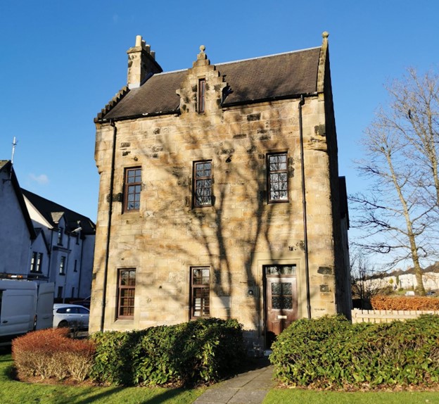
Ref: The Tower (18 and 20 Castlefield Court) pictured 2023. Photo by Kayleigh Hirst
Hogganfield Park
Although the village of Millerston had been built on the shores of Hogganfield Loch, the land around the loch was mostly privately owned. At this time, Millerston lay within the boundary of the county of Lanarkshire - nevertheless, Glasgow Corporation (a precursor to Glasgow City Council) had by 1915 made several attempts to purchase the land around the loch with the intention of creating a public park.
This was at a time when the city was ramping up its creation of dedicated public park spaces, including Kelvingrove Park in the west end of the city and Queen’s Park in the south. It was all part of an effort to improve the health of its citizens, providing clean air and exercise away from the noisy and polluted city.
Ref: Hogganfield Park in 1924. Image: ‘Lost Glasgow’.
View on Facebook
Lying just three miles from Glasgow city centre, but far enough away to still enjoy clean air, Hogganfield was a prime candidate for development. However, Glasgow Corporation found it was not as easy as they had hoped to purchase the land - local landowners were reluctant to sell, including Mary Pinkerton, whose family-owned rhubarb fields all around, and who clearly did not want the peace and tranquillity of the area disturbed. She objected to the plans on the grounds it would bring “crowds of people” to the loch.
Eventually, Glasgow Corporation managed to buy enough of the land needed to make a public park – including the old Millerston School, purchased from Lanark County Council in 1924 for £800.
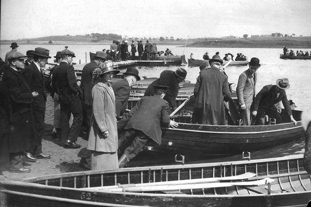
They soon began improvement works and put around 100 unemployed people to work to build the two-and-a-half-mile long promenade around the loch. What had been a connected peninsula on the east side of the loch was cut through to form a picturesque island, which later became an important bird sanctuary. The loch was also deepened to allow for boating, and in July 1924, the park was formally opened to the public, with a hundred rowing boats and two motor boats provided for the first visitors.
Trams
Coinciding with the opening of this new public park, the Glasgow tramway network was extended from Riddrie to Millerston in the same month. A new terminus and turning area was built on Station Road, and meant Millerston residents could get to Glasgow in half an hour - and vice versa.
On opening night in July 1924, the Kirkintilloch Herald newspaper reported the excitement at this novelty for local residents:
The sidewalk of the road between Stepps and Millerston was unusually thronged on Sunday evening. The greater part of the crowd was composed of Glasgow people, who had been sampling the newly opened car line [trams] to Millerston Terminus, while the remaining part was made up of Stepps residents whom the novelty had sauced to take their evening walk in that direction.
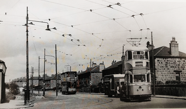
Ref: Millerston tram terminus, pictured in the late 1950s. Image taken from ‘Old Riddrie, Millerston and Stepps’, John Hood, Stenlake Publishing, 2001.
Trams had been a popular mode of transport in Glasgow since the first lines were built for horse-drawn vehicles in 1872. By the 1920s the greater Glasgow area would have over 100 miles of tracks (although now for electrified vehicles), and be one of the largest urban tramway systems in Europe.
By the 1950s the trams were being replaced with buses and trolley buses, and the lines closed one by one. In March 1959, the Millerston-Rouken Glen-Giffnock Road service was withdrawn and the last tram left Millerston terminus.
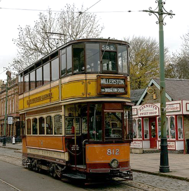
Ref: A Glasgow Corporation tramcar, heading for Millerston. Photo: Caingram.
https://www.caingram.info/Scotland/Pic_htm/glasgow_tram_5.htm
Millerston Moves East
Although the 1920s had brought the excitement of trams to Millerston, the first decades of the 20th century were also a hard time for the community. Having previously been described as being “occupied by the poorest class”, things had not greatly improved, and a newspaper report of 1914 described the housing at Millerston as a “public health danger”, with conditions the worst in the lower ward of Lanarkshire, and reported that “Millerston was not fit to live in - from end to end it was putrid… People were living in hovels [you] would not put your dog into”.
Around this time there was clearly tension between the authorities of the Lower Ward of the County of Lanark and those of Glasgow Corporation, over whose responsibility it was to build and maintain housing for the working class of the area.
When Glasgow Council proposed absorbing Millerston within the city boundaries in 1924, the Lower Ward District Committee called a meeting of local residents to rally them behind their motion to object to the plans. They were keen to begin building the 1,000 houses they had recently been granted permission to erect by the Board of Health, which were expected to bring in rents of £19 a year (£1,400 in today’s money).
Despite the strength of feeling from the Lower Ward committee and the residents, Millerston did became part of Glasgow in 1926. (It has since been rezoned again, and now most of the community lies within North Lanarkshire - except the newer houses of Millersneuk Crescent, which remain in Glasgow).
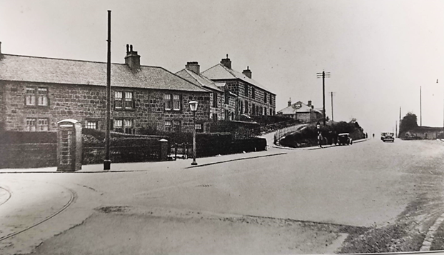
Ref: Cumbernauld Road, Millerston pictured in 1937. East Dunbartonshire Archives
Around this time, the older houses of the village were being demolished due to their poor state, with their inhabitants moved elsewhere. Gradually, the new community of Millerston began to grow further to the east, to the north side of Cumbernauld Road, on what had formerly been the fields of Coshnockmuir Farm (a corruption of whose name, Coshneuk, survives in the name of Coshneuk Road).
Recent Years in Millerston
Since the shift of the community east along Cumbernauld Road, Millerston has grown further, with a spate of new housing estates built in the 1980s: Lochview (1984), Millersneuk (1985) and Willow Park (1989).
The community has also become home to Strathclyde University’s playing fields, with the university having purchased their first piece of land in the area in 1964. Facilities at the site now include a floodlit synthetic hockey pitch, a grass lacrosse pitch, two rugby pitches and five football pitches.
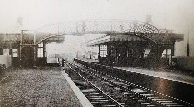
Ref: The original Robroyston train station, date unknown. Image taken from Old Riddrie, Millerston and Stepps’, John Hood, Stenlake Publishing, 2001.
The people who have made Millerston their home in recent years have been attracted by the community’s setting next to picturesque Hogganfield Loch, and its close proximity to Glasgow, with transport links improving with the reopening of Robroyston station in 2019.
The original Robroyston station was opened on the Glasgow to Garnkirk railway line in 1898, although with Millerston village still in its original position further west at that point, people travelling to and from Glasgow had quite a walk to reach it. The line operated for 58 years before closing to passengers in June 1956.
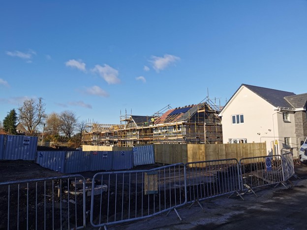
Ref: New houses being built off Cumbernauld Road, 2023. Photo by Kayleigh Hirst
In 2017 plans were lodged to build a new train station to replace the original one at Robroyston, and the first passenger trains began running out of the new stop again in 2019. Despite being arguably closer to the new, expanded community of Millerston than it is to Robroyston - now a convoluted 20-minute walk away crossing beneath the M80 motorway - the station retains its original name of Robroyston.
Having once been a name familiar to many as a terminus station seen on the front of Glasgow’s beloved trams, Millerston is now a lesser-known suburb of Glasgow. Where the houses built between the 1920s and 1980s shifted the centre of the community to the east, houses are once again returning to the original heart of Millerston, with new homes currently being erected between the United Free Church and the playing fields of St Aloysius College.
N.B. With sincere thanks to Freda Bunyan for providing additional material for this chapter.